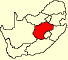
Free State
The Free State lies in the heart of South Africa, with the Kingdom of Lesotho nestling in the hollow of its bean-like shape. Between the Vaal River in the north and the Orange River in the south, this immense rolling prairie stretches as far as the eye can see. 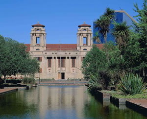 The capital, Bloemfontein, has a well-established institutional, educational and administrative infrastructure, and houses the Supreme Court of Appeal. The province has a well-known university and many other training institutions.
Important towns include Welkom, the heart of the goldfields and one of the few completely pre-planned cities in the world; Odendaalsrus, another gold-mining town; Sasolburg, which owes its existence to the petrol-from-coal installation established there; Kroonstad, an important agricultural, administrative and educational centre; Parys on the banks of the Vaal River; Phuthaditjhaba, well known for the beautiful handcrafted items produced by the local people; and Bethlehem, gateway to the Eastern Highlands of the Free State.
The capital, Bloemfontein, has a well-established institutional, educational and administrative infrastructure, and houses the Supreme Court of Appeal. The province has a well-known university and many other training institutions.
Important towns include Welkom, the heart of the goldfields and one of the few completely pre-planned cities in the world; Odendaalsrus, another gold-mining town; Sasolburg, which owes its existence to the petrol-from-coal installation established there; Kroonstad, an important agricultural, administrative and educational centre; Parys on the banks of the Vaal River; Phuthaditjhaba, well known for the beautiful handcrafted items produced by the local people; and Bethlehem, gateway to the Eastern Highlands of the Free State.
The road network density of the province is the third-highest in the country. The big national road, which is the artery between Gauteng and the Western and Eastern Cape, passes through the middle of the Free State.
The people
The Free State is the third-largest province in South Africa. However, it has the second- smallest population and the second-lowest population density. It houses some 2,8 million people on about 129 480 km2 of land. The main languages spoken are Sesotho and Afrikaans. Some 16% of people aged 20 years or older have had no schooling. The official unemployment rate according to Statistics South Africa is 23,3%.
Many of the towns display a mix of culture clearly evident in street names, public buildings, monuments and museums. Dressed sandstone buildings abound on the Eastern Highlands, while beautifully decorated Sotho houses dot the grasslands. Some of South Africa's most valued San 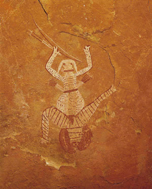 rock art is found in the Free State. The districts of Bethlehem, Ficksburg, Ladybrand and Wepener have remarkable collections of this art form. rock art is found in the Free State. The districts of Bethlehem, Ficksburg, Ladybrand and Wepener have remarkable collections of this art form.
Agriculture
This summer-rainfall region can be extremely cold during the winter months, especially towards the eastern mountainous regions where temperatures can drop as low as 9,5C. The western and southern areas are semidesert.
Known as the 'granary of the country', the Free State has cultivated land covering 3,2 million ha, while natural veld and grazing cover 8,7 million ha.
Field crops yield almost two-thirds of the gross agricultural income of the province. Animal products contribute a further 30%, with the balance coming from horticulture.
Ninety per cent of the country's cherry crop is produced in the Ficksburg district, while the two largest asparagus canning factories are also situated in this district. Soya, sorghum, sunflowers and wheat are cultivated, especially in the eastern Free State, where farmers specialise in seed production. About 40% of the country's potato yield comes from the high-lying areas of the Free State.
Mining
The Free State contributes about 16,5% of South Africa's total mineral output.
The mining industry is the biggest employer in the Free State and is responsible for some 22,6% of GGP of the province. Investment opportunities are substantial in productivity-improvement areas for mining and related products and services.
South Africa is the world's largest producer of gold. A more than 400-km long gold reef, known as the goldfields, stretches across Gauteng and the Free State, the largest gold-mining complex being Free State Consolidated Goldfields with a mining area of 32 918 ha.
Some 82% of the region's mineral production value is derived from this activity, primarily in the Goldfields region, which comprises the districts of Odendaalsrus, Virginia and Welkom. Roughly 30% of South Africa's gold is obtained from this region, and the province qualifies for fifth position as a global producer.
The Harmony Gold Refinery situated in Virginia is allowed to sell one-third of its total annual gold production to jewellery manufacturers, and has the facilities to ensure that the correct quality is maintained at all times. Harmony Gold Refinery and Rand Refinery are the only two gold refineries in South Africa. The large-scale mining activities of the Free State Goldfields serve as an additional stimulus for further development.
Gold mines in the Free State also supply a substantial portion of the total silver production of the country, while considerable concentrations of uranium occurring in the gold-bearing conglomerates of the goldfields are extracted as a by-product.
Bituminous coal is mined in the province and converted to petrochemicals at Sasolburg.
Diamonds from this region, extracted from kimberlite pipes and fissures, are of a high quality.
The largest deposit of bentonite in the country occurs in the Koppies district.
Manufacturing
Manufacturing is the second-largest sector in the regional economy. Among the most important activities are the chemical products manufactured by Sasol and the further beneficiation of agricultural products. A wide variety of industries have developed around the production of basic chemicals from coal.
Tourism
The boundless plains of Sourfi Africa's interior plateau between the Vaal and Orange Rivers form the Free State Province, South Africa's geographical heart.
Known locally as South Africa's 'bread basket', the Free State earth is cultivated by more than 30 000 farms to produce over 70% of South Africa's grain consumption. It is also dug into by some of me most productive gold and diamond mines in the world, and is inhabited by more than 4 million people. Reassuringly however, nature rules supreme in the Free State despite the developments that have been made by its human occupants.
The South shares the true Karoo semi-desert like a determined climber over the precipice of barrenness. The North, fed by the Vaal River, indulges gleefully in the richness of the percolated countryside. The West hustles and bustles proudly across savannah land of substantial mineral wealth, while the highlands of the East smile placidly from their mountain-tops, flashing inimitable natural splendour upon envious eyes below.
This land of the windpomp and krummelpap is the geographic and agricultural centre of South Africa, of the extinct quaggo,of wars/ of natural springs and most of all open space. The landlocked but aptly-named Free State is a vast grassy platform for me soul to take flight and the spirit to break free.
FREE STATE TOURIST ROUTES
Maluti Route
This route takes you through the scenic Highlands of the Free State and over the border (remember your passport) into the magnificent Maluti mountains of Lesotho and ends at the RAMSAR accredited Seekoelvlei Nature Reserve at Memel.
Goldfields Route
Follow the fascinating history of the many gold mines of the Lejweleputswa area. Take a trip to a gold mine and watch them cast an ingot of this precious metal.
BBT Heritage Route
Bloemfontein, Botshabelo and Thaba Nchu are in close geographical relationship to each other yet have on extreme diverse cultural and political heritage, come discover it!
Diamond & Wine Route
Follow the route of the diamond prospectors of the past and present on this route.At Jagersfontein is a man-made diamond hole of 760m that rivals the better known Big Hole of Kimberley for size.Also visit the wine cellars of Landzicht and Wilreza in the Jacobsdal area.
N6 Route
Take the N6 to either exit or enter the Free State from the south. This route takes you through quaint Xhariep and Eastern Cape towns and on to East Londen, the Wild Coast and Garden Route.
Kindly supplied by The Director of South African Tourism |